Mt. Tokachi

Location: Hokkaido
Elevation: 2,077 m
1/25000 map: Tokachidake (十勝岳), Shirogane Onsen (白銀温泉)
Season for hikers: late April to early October
The highest peak of the Daisetsu mountains continuing volcanic activity
Mt. Tokachi, the highest peak in the Tokachi mountains is still actively raising volcanic smoke. A caution to the weather condition and volcanic activity needs to be checked before hiking. Mt. Tokachi consists of collapsed slope by eruption and narrow ridgeline, and there are few alpine plants around the peak.
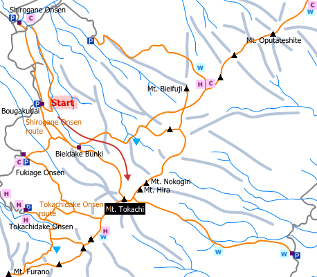
Sample hiking route
Distance (round trip): 10.2 km
Distance in elevation: 1,147 m
Difficulty during the best season: intermediate level
Trailhead: Bougakudai
Route and estimated course time:
Bougakudai -(0:50)- Bieidake Bunki (Mt. Biei blanch) -(2:30)- Mt. Tokachi -(1:30)- Bieidake Bunki -(0:40)- Bougakudai [6:30 in total]
Note: It is a gentle slope until a shelter. Then, the route becomes difficult to walk through because it is steeper and covered with sand gravel. It is easier to lose way in foggy days.
Sample hiking route map

Hiking report
It is not available yet.
Directions
Public transportation
Haneda Airport (Tokyo) -[Airline]- Asahikawa Airport -[Furano Bus]- Biei Station -[taxi]- Bougakudai (trailhead)
Flight information/Timetable:
Haneda Airport to Asahikawa Airport: Fly Team
Asahikawa Airport to Biei Station: Furano Bus
Hot bath after hiking
Yumoto Shirogane-onsen Hotel(湯元白金温泉ホテル)
Fee: 800 yen/adult
Bathing time: 11:00-17:00
Telephone: 0166-94-3333


