Mt. Oku-Hotaka
Location: Nagano, Gifu
Elevation: 3,190 m
A holy ground for alpinists where the modern alpinism in Japan has developed
Mt. Hotaka is a general term of Mt. Okuhotaka, Mt. Nishihotaka, Mt. Maehotaka and Mt. Kitahotaka. Mt. Hotaka is consit of rugged rocky ridges so that there are many radders and chains on hiking routes. This mountain is also famous for rock climbing. Karasawa is a base camp for hikes and a tent village emerges during hiking season.
Hiking
There are several routes to Mt. Oku-Hotaka. Two routes shown here are examples. Those should be a multiday hike.
- From Kamikouchi: 16 hours 30 minutes (36 km)
- From Shin-Hotaka Onsen: To be noted
Sample route
Route: From Kamikouchi
Distance: 36 km
Distance in elevation: 1,685 m
Difficulty during the best season: advanced level
Season for hikers: July to early October
Route and estimated course time:
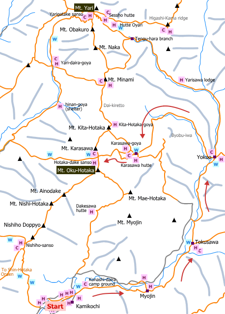
Kamikouchi -[0:55]- Myojin -[1:00]- Tokusawa -[1:10]- Yokoo -[1:20]- Hondani-bashi -[1:40]- Karasawa -[2:30]- Hotaka-dake sanso -[0:50]- Mt. Hotaka -[0:40]- Hotaka-dake sanso -[1:30]- Karasawa -[1:00]- Hondani-bashi -[0:50]- Yokoo -[1:10]- Tokusawa -[1:00]- Myojin -[0:55]- Kamikouchi [16 hours 30 minutes]
Description:
It is almost a smooth road from Kamikochi to Yokoo. Yokoo is a branch to Mt. Yari, Mt. Hotaka (via Karasawa) and Mt. Cho. The roue is along a stream after crossed Yokoo O-hashi (Yokoo bridge). The is a big wall called ‘Byobu-iwa’ which is famous for rock climbing. From Hontani-bashi (Hontani bridge), the trail becomes steeper and a zigzag bath until Karasawa. From Karasawa, there are two routes. Those are joined into one again on the way to the mountain ridge. Select ‘panorama route’ and, after joined, there are ladders and chains. Hotaka-dake sanso is almost there. There are ladders and chains on the route to Mt. Hotaka. Route to Mt. Nishi-Hotaka from Mt. Hotaka is recognized as the most toughest normal route in Japan. From the peak of Mt. Oku-Hotaka, Landscape for 360 degrees, including the landscape of the mountains to Mt. NIshihotaka, can be enjoyed.
Route map

Hiking report
It is not available yet.
Directions
Public transportation
- From Kamikouchi: Mastsumoto station -(local train)- Shin-Shimashima -(bus)- Kamikochi
- From Shin-Hotaka Onsen: Matsumoto station -(bus)- Shin-Hotaka Onsen
Area information
Hot bath after hiking
Hirayu Onsen(奥飛騨温泉郷 平湯温泉)
Fee: 500 yen/adult
Bathing time: 10:00-21:00
Telephone: 0578-89-3338


