Mt. Shiribeshi

Location: Hokkaido
Elevation: 1,898 m
1/25000 map: Youteizan (羊蹄山), Kucchan (倶知安)
Season for hikers: late May to early October
A stratovolcano, the beautiful shape of a mountain, called ‘Ezo-Fuji’
The shape of Mt. Shiribeshi looks like beautiful Mt. Fuji. Mt. Shiribeshi is called ‘Maneshiri’ (Female mountain) in Ainu language, and is a couple mountain together with Mt. Poroshiri (called ‘Pinneshiri’, meaning male mountain in Ainu). Mt. Shiribeshi is also called ‘Mt. Yotei’. There are many kinds of alpine plants. A part of the mountain is located in Shikotsu-Toya national park.
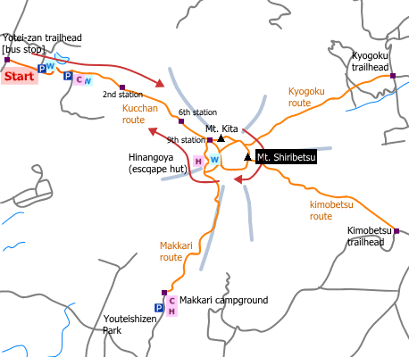
Sample hiking route
Distance (round trip): 16.2 km
Distance in elevation: 1,660 m
Difficulty during the best season: advanced level
Trailhead: Yoteizan tozanguchi
Route and estimated course time:
Yoteizan tozanguchi -(1:30)- 2nd Station -(1:50)- 6th Station -(2:40)- Mt. shiribeshi -(2:50)- 6th Station -(1:00)- 2nd Station -(1:00)- Yoteizan tozanguchi [10:50 in total]
Note: There are four routes to the peak of Mt. shiribeshi. Every route requires to climb more than 1,500 m in distance of elevation. It is a tough hiking because the slop of a lean of 30° continues to the peak.
Sample hiking route map

Hiking report
It is not available yet.
Directions
Public transportation
Haneda Airport (Tokyo) -[Airline]- Shin-Chitose Airport (Sapporo) -[JR Hokkaido]- Kucchan -[Donan Bus]- Yoteizan tozanguchi (Mt. Yotei traihead)
Flight information/Timetable:
Haneda Airport to Shin-Chitose Airport: Big Bird
Shin-Chitose Airport to Kucchan: Grand Hirafu
Kucchan to Yoteizan tozanguchi: Donan Bus
Hot bath after hiking
Niseko Grand Hotel(ニセコグランドホテル)
Fee: 700 yen/adult
Bathing time: 11:30-22:00
Telephone: 0136-58-2121


