Mt. Zao

Location: Yamagata, Miyagi
Elevation: 1,841 m
1/25000 map: Zao-san (蔵王山)
Season for hikers: early May to late October
Mt. Zao, a mountain of volcano and mountain worship, commands a marvelous view
Mountains including Mt. Gando (northen part) and Mt. Fubo (southern part) are called Zao mountains, and a mountain range around Mt. Kumano, the highest peak, is called Mt. Zao. Many tourists visit Okama, a huge crater lake and a symbol of Mt. Zao, given the opening of the road to Mt. Katta where a shrine venerating Zao Gongen, which is between Buddha of Buddhism and the gods of Shinto religion, existed in the old days.
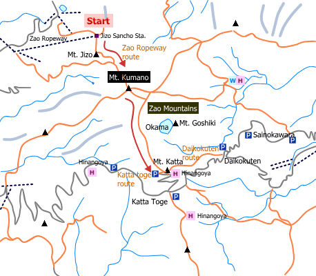
Sample hiking route
Distance (round trip): 3.9 km
Distance in elevation: 181 m
Difficulty during the best season: beginner level
Trailhead: Jizo Sancho Station (Zao Ropeway)
Route and estimated course time:
Jizo Sancho statoin -(0:25)- Iroha Pond -(0:25)- Mt. Kumano -(0:45) Mt. Katta [1:35 in total]
Note: This is the shortest route to the peak of Mt. Zao.
Sample hiking route map

Hiking report
It is not available yet.
Directions
Public transportation
Tokyo Station -[JR Yamagata Shinkansen]- Yamagata Station -[Yamako Bus]- Zao Onsen
Flight information/Timetable:
Tokyo Station to Yamagata Station: Ekitan
Yamagata Station to Zao Onsen: Yamako Bus
Hot bath after hiking
Shinzaemon-no-yu(新左衛門の湯)
Fee: 700 yen/adult
Bathing time: 10:00-21:30
Telephone: 023-693-1212


