Mt. Tsurugi (Tsurugi-san)
Name in Japanese: Tsurugi-san (剣山)
Location: Tokushima
Elevation: 1,955 m
A mountain known from the legend of concerning a fugitive clan (Heike no Ochudo legend)
Mt. Tsurugi (Tsurugi-san) is a gentle shaped mountain although the kanji character of Tsurugi (meaning ‘soword’ in English) implies a steep mountain. Even beginners can easily step on the peak of the mountain by using a lift. The name in Tsurugi originated from the legend that emperor Antoku laid his soword on the peak. Flowers are blooming along promenades in summer.
Hiking
- From Minokoshi: 2 hours 55 minutes (4.9 km)
Sample route
Route: From Minokoshi
Distance: 4.9 km
Distance in elevation: 560 m
Difficulty during the best season: beginner level
Season for hikers: April to early November
Route and estimated course time:
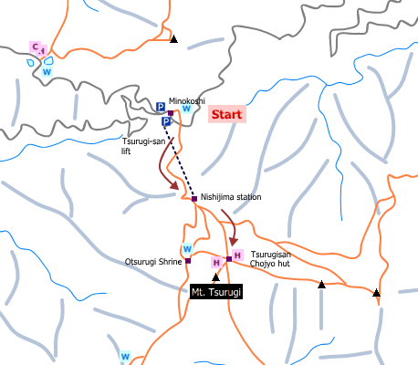
Minokoshi –[0:50]- Nishijima station –[0:45]- Tsurugisan Chojyo hut –[0:05]- Mt. Tsurugi –[0:30]- Nishijima station –[0:35]- Minokoshi [2 hours 55 minutes]
Description:
The route is in good condition. There are several routes to Mt. Tsurugi and all of them are not tough due to a gentle slope.
Route map

Hiking report
It is not available yet.
Directions
Public transportation
- Minokoshi: Sadamitsu station -(special bus runs only in summer)- Minokoshi
Area information
To be Noted


