Mt. Shiomi
Name in Japanese: Shiomi-dake (塩見岳)
Location: Shizuoka, Nagano
Elevation: 3,047 m
Mountain with a great view located in centrral part of southern Alps
Mt. Shiomi, a helmet of armor shaped mountain, is located in the cental and deepest part of southern Alps. It has twin peaks and East peak is higher. Although a route walk through a primeval forest is recommendable, it rquires to stay 2 nights in the mountain. The view of mountains in southern Alps from the summit is very beautiful.
Hiking
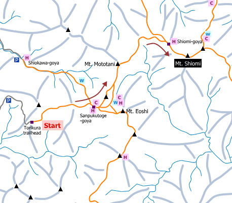
There are several routes to Mt. Shiomi. The route shown here is popular for hikers.
- From Torikura trailhead: 13 hours (18 km)
Sample route
Route: From Torikura trailhead
Distance: 18 km
Distance in elevation: 1,282 m
Difficulty during the best season: advanced level
Season for hikers: June to October
Route and estimated course time:
Torikura trailhead -[3:00]- Sanpukutoge-goya -[1:30]- Mt. Mototani -[1:50]- Shiomi-goya -[1:30]- Mt. Shiomi -[1:00]- Shiomi-goya -[1:30]- Mt. Mototani -[0:50]- Sanpukutoge-goya -[1:50]- Torikura trailhead [13 hours]
Description:
The route to Sanpukutoge-goya is in good condition. To Shiomi-goya, there are ups and downs, and there are zigzag paths occasionally, but they are not so hard. On the way to Shiomi-goya, fine view from Mt. Mototani and Shiomi-goya is expected. The rocky route just before the peak is kind of steep. Be careful not to roll rocks. Inexperienced hikers may feel difficult because there are no chains/ropes. From the peak, it overlooks mountains of the South Alps.
Route map

Hiking report
It is not available yet.
Directions
Public transportation
- From Torikura trailhead: Ina-Oshima station -(bus)- Torikura trailhead
Area information
Hot bath after hiking
Seiryu-en ( 信州まつかわ温泉 清流苑)
Fee: 400 yen/adult
Bathing time: 10:00-20:00
Telephone: 0265-36-2000


