Mt. Shari

Location: Hokkaido
Elevation: 1,547 m
1/25000 map: Sharidake (斜里岳)
Season for hikers: late June to October
Beautiful shaped mountain in eastern Hokkaido
Mt. Shari sits on the border between the Shiretoko mountains and the Akan mountains. Mt. Shari is a composite volcanoand with a shape resembling Mt. Fuji, a beautiful shaped mountain. The route from Seigakuso, a mountain hut, is popular with riverside trekking and ridgeline walking with great view, as well as alpine plants.
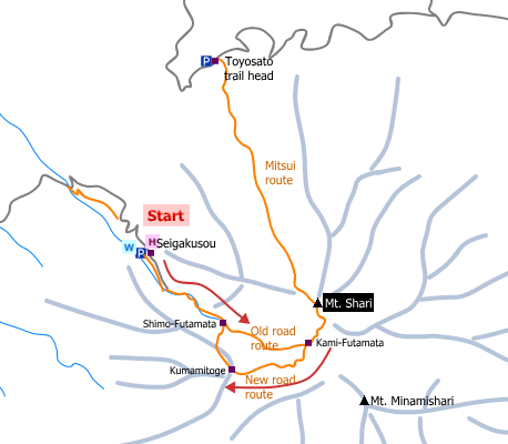
Sample hiking route
Distance (round trip): 8.1 km
Distance in elevation: 877 m
Difficulty during the best season: intermediate level
Trailhead: Seigakuso
Route and estimated course time:
Seigakuso -(0:40)- Shim-ofutamata -(0:50)- Kami-futamata -(1:00)- Mt. Shari -(0:40)- Kami-futamata -(1:10)- Shimo-futamata -(0:30)- Seigakuso [4:50 in total]
Note: The route from Seigakuso divides into two lines at Shimo-futamata. Many hikers walk the old route (along a river) to the peak and chose the new road for the downhill way.
Sample hiking route map

Hiking report
It is not available yet.
Directions
Public transportation
Haneda Airport (Tokyo) -[Airline]- Kushiro Airport -[Airport Bus]- Kushiro Station -[JR Hokkaido]- Kiyosatocho -[taxi]- Seigakuso (trailhead)
Flight information/Timetable:
Haneda Airport to Kushiro Airport: Big Bird
Kushiro Airport to Kushiro Station: Kushiro Airport
Kushiro Station to Kiyosatocho Station: JR Hokkaido
Hot bath after hiking
Ryokuseiso (ホテル緑清荘)
Fee: 380 yen/adult
Bathing time: 10:00-22:00
Telephone: 0152-25-2281


