Mt. Rausu

Location: Hokkaido
Elevation: 1,661 m
1/25000 map: Rausu (羅臼), Iozan (硫黄山), Shiretoko-goko (知床五湖)
Season for hikers: late June to October
The highest peak in the Shiretoko mountains, located in a World Heritage site
Mt. Rausu is the highest peak in Shiretoko and dormant volcano in Chishima volcanic zone. The bell-shaped summit is formed by lava dome, piled up with impressively strange and huge rocks. The magnificent nature surrounded by untouched primeval forests remains in this area.
Sample hiking route
Distance (round trip): 13.8 km
Distance in elevation: 1,476 m
Difficulty during the best season: intermediate level
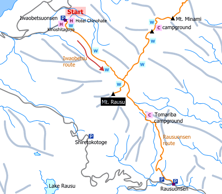
Trailhead: Iwaobetsu Onsen
Route and estimated course time:
Iwaobetsu Onsen -(1:30)- Yamikichimizu -(1:45)- Rausudaira -(0:50)- Mt. Rausu -(0:40)- Rausudaira -(1:20)- Yamikichimizu -(1:10)- Iwaobetsu Onsen [7:15 in total]
Note: This route is easiler than the other route but the distance in elevation is more than 1,400 m; meaning that it is kind of a tough route for inexperienced hikers.
Sample hiking route map

Hiking report
It is not available yet.
Directions
Public transportation
Haneda Airport (Tokyo) -[Airline]- Shin-Chitose Airport (Sapporo) -[Chuo Bus]- Utoro Onsen Bus Terminal -[taxi]- Iwaobetsu Onsen (trailhead)
Flight information/Timetable:
Haneda Airport to Shin-Chitose Airport: Big Bird
Shin-Chitose Airport to Utoro Onsen Bus Terminal: Hokkaido Chuo Bus
Hot bath after hiking
Yuhi-dai-no-yu (夕日台の湯)
Fee: 500 yen/adult
Bathing time: 14:00-20:00
Telephone: 0152-23-3131


