Mt. Omine
Location: Nara, Mie
Elevation: 1,915 m
A mountain has been a grand head temple of ascetic practice and is still inaccessible to woman
Mt. Omine is a mountain range between Mt. Yoshino and Kumano. The highest peak is Mt. Hakkyo (Hakkyo-ga-take). Mt. Sanjyo (Sanjo-ga-take) is known for the mountain a mountain inaccessible to woman. Mt. Omine, covered with a primeval forest, is truly a natural treasury where magnolia sieboldii, a natural treasure, blooms. An ancient pilgrimage route from Omine to Kumano is a part of World Heritage (Sacred Sites and Pilgrimage Routes in the Kii Mountain Range).
Hiking
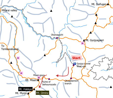
- From Gyojya tunnel West exit: 6 hours 30 minutes (8.8 km)
Sample route
Route: From Gyojya tunnel West exit
Distance: 8.8 km
Distance in elevation: 785 m
Difficulty during the best season: intermediate level
Season for hikers: late April to October
Route and estimated course time:
Gyojya tunnel West exit –[1:00]- Okugakemichi branch –[1:10]- Ruine of Seihou-no-yado –[1:00]- Mt. Misen –[0:40]- Mt. Hakkyo –[0:25]- Misen-goya –[0:35]- Ruine of Seihou-no-yado –[1:00]- Okugakemichi branch –[0:40]- Gyojya tunnel West exit [6 hours 30 minutes]
Description:
The route starts with a steep slope. The trail along the river valley is a muddy road, so it is slippery especially in rainy weather. From Okugakemichi branch, the trail on a mountain ridge is easy to walk on although there are ups and downs. It becomes steeper again before arriving Misen-goya. Mt. Hakkyo is less than 1 hour walk from Misen-goya.
Route map

Hiking report
It is not available yet.
Directions
Public transportation
- Gyojya tunnel West exit: Shimo-Ichiguchi station -(bus)- Tenkawa-Kawai -(taxi)- Gyojya tunnel West exit
Area information
To be Noted


