Mt. Odaigahara
Name in Japanese: Odaigahara (大台ケ原)
Location: Nara, Mie
Elevation: 1,695 m
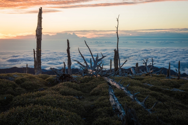
A mountain with various looks such as a primeval forest, a precipice and wild deers in Kii Peninsula
Mt. Odaigahara is a paradice on the mountain where wild deers play in a cluster. The view from the highest peak, Mt. Hidegatake, provides a panorama view of Omine Mountains and Kumano-nada Sea. Kii Peninsula is one of regions that have a large amount of rainfall in Japan. The plentiful rain, over 4800 mm of annual rainfall, germinates plenty of plants in this area.
Hiking
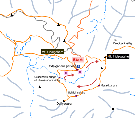
- Oaigahara parking: 3 hours 40 minutes (6.9 km)
Sample route
Route: From Oaigahara parking
Distance: 6.9 km
Distance in elevation: 125 m
Difficulty during the best season: beginner level
Season for hikers: late April to October
Route and estimated course time:
Oaigahara parking –[0:40]- Mt. Hidegatake –[0:30]- Masakigahara –[0:25]- Ushiishigahara –[0:25]- Daijyagura –[1:00]- Suspension bridge of Shiokaradani valley –[0:40]- Oaigahara parking [3 hours 40 minutes]
Description:
The route is almost flat. Landscape for 360 degrees can be enjoyed on the peak of Mt. Hidegatake. Odaigahara is classified broadly into two parts, namely, East-Odai known for landscape of Mt. Hidegatake and Daijyagura, and West-Odai known for the natural forest area.
Route map

Hiking report
It is not available yet.
Directions
Public transportation
- Oaigahara parking: Yamato-Kamiichi station -(bus)- Oaigahara parking
Area information
To be Noted


