Mt. Kiso-Komagatake
Name in Japanese: Kiso-Komagatake (木曽駒ヶ岳)
Location: Nagano
Elevation: 2,956 m
The primary peak of Central Alps having beautiful cirque
Mt. Kiso-Komagatake is the highest mountain of Central Alps that measured 80 km from north to south. There is a beautiful cirque on the southeast face of the mountain. Lots of alpine flowers blooms in the season. Many tourists visit the cirque area (Senjojiki cirque) since it is easily accessible by ropeway.
Hiking
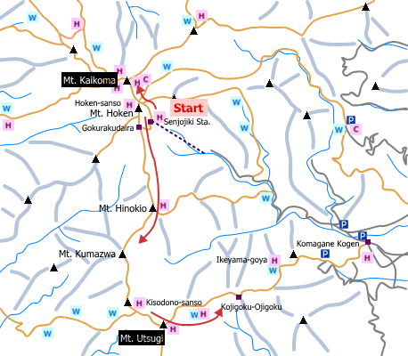
There are several routes to Mt. Kiso-Komagatake. The route shown here is easy one.
- From Senjojiki ropeway station: 2 hours 40 minutes (4.4 km)
Sample route
Route: From Senjojiki ropeway station
Distance: 4.4 km
Distance in elevation: 316 m
Difficulty during the best season: beginner level
Season for hikers: late June to late October
Route and estimated course time:
Senjojiki ropeway station -[0:40]- Hoken-sanso -[0:50]- Mt. Kiso-Komagatake -[0:40]- Hoken-sanso -[0:30]- Senjojiki ropeway station [2 hours 40 minutes]
Description:
The ropeway is very crowed in summer and colored leaves in the fall. It is recommended to got the ropeway station early. There are steep stairways until Hoken-sanso although distance in elevation for this route is only 311 meters. If you want to step the peak of Mt. Hoken, be careful at chain places on rocky areas. This should be severe for beginners. It is a gentle slope from Hoken-sanso to the peak of Mt. Kiso-komagatake.
Route map

Hiking report
It is not available yet.
Directions
Public transportation
- From Senjojiki ropeway station: Komagane station -(bus)- Shirabi-daira -(ropeway)- Senjojiki
Area information
Hot bath after hiking
Komakusa-no-yu ( こまくさの湯)
Fee: 610 yen/adult
Bathing time: 10:00-21:00
Telephone: 0265-81-8100


