Mt. Kaimon
Name in Japanese: Kaimon-dake (開聞岳)
Location: Kagoshima
Elevation: 924 m
A beautiful corn-shaped mountain called as Satsuma-Fuji
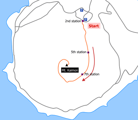
Mt. Kaimon is an individual mountain, located southern tip of the Satsuma Peninsula, rises 924 meters above sea level. It is a beautiful corn-shaped dormant volcano and it is also called as Satsuma-Fiji (its shape resembles Mt. Fuji). The trailhead is just the sea level. The route spirals up the mountain. The view from the summit is very beautiful and provide a view of distant islands.
Hiking
- From 2nd station: 4 hours 30 minutes (8.0 km)
Sample route
Route: From 2nd station
Distance: 8.0 km
Distance in elevation: 724 m
Difficulty during the best season: beginner level
Season for hikers: late April to early November
Route and estimated course time:
2nd station –[1:00]- 5th station –[0:30]- 7th station –[1:10]- Mt. Kaimon –[0:50]- 7th station –[0:20]- 5th station –[0:40]- 2nd station [4 hours 30 minutes]
Description:
After crossing Kyushu Nature Trail, the uphill trail runs without branching. It becomes a broad visual field for the east side at 5th station. Then , the trail becomes rocky. The south side can be visual at 7th station. In sunny day, Yakushima Island can see from there. The peak is after passing a steep slope and ladder place just directly under the mountain top.
Route map


Hiking report
It is not available yet.
Directions
Public transportation
- 2nd station: Kaimon station -(40-minutes walk)- 2nd station
Area information
To be Noted


