Mt. Iwate

Location: Iwate
Elevation: 2,038 m
1/25000 map: Ubayashiki (姥屋敷), Obuke (大更), Matsukawa Onsen (松川温泉)
Season for hikers: July to early October
A mountain with beautiful shape, referred to as Iwate-Fuji
Mt. Iwate is also called “Southern half-Fuji” as a half of the shape illustrates graceful curve and the other half exhibits the jagged intense volcano wall. Due to the volcanic earthquake, hiking was regulated for a while. It is desirable to confirm pre-eruption alert level (Meteorological Agency) before hiking as volcanic activity still continues.
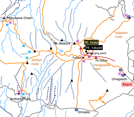
Sample hiking route
Distance (round trip): 11.1 km
Distance in elevation: 1,408 m
Difficulty during the best season: intermediate level
Trailhead: Umagaeshi
Route and estimated course time:
Umagaeshi -(3:05)- 7th station -(0:50)- Ohachi-no-Kakofuchi -(0:20)- Mt. Yakushi (Mt. Iwate) -(1:05)- 7th station -(2:45)- Umagaeshi [8:05 in total]
Note: The route is in good condition and there are many hikers. There is no remarlable dangerous part of the route. There are two routes (old route and nre route). Old route has nice view while new route is safer. One day hike is possible but it is better stay at a shelter hut at 8th station for inexperienced hikers.
Sample hiking route map

Hiking report
It is not available yet.
Directions
Public transportation
Tokyo Station -[JR Tohoku Shinkansen]- Morioka Station -[taxi]- Umagaeshi (traihead)
Flight information/Timetable:
Tokyo Station to Morioka Station: Ekitan
Hot bath after hiking
Oyamanoyu(お山の湯)
Fee: 400 yen/adult
Bathing time: 10:00-21:00
Telephone: 019-680-2588


