Mt. Iide

Location: Yamagata, Fukushima, Niigata
Elevation: 2,128 m
1/25000 map: Kawairi (川入), Dainichi-ake (大日岳), Iide-san (飯豊山), Chojyahara (長者原)
Season for hikers: early May to late October
A long course in the heavy snowfall area; high degree of difficulty for hiking
Iide Mountains, ranging about 2,000 m high mountains, is the greatest massif in Tohoku. It is a deep and steep mountain with flowers and lots of remaining snow, and therefore, it is a difficult route. The highest peak in Iide Mountains is Mt. Dinichi, while Mt. Iide’s, the primary peak, is the object of mountain worship. In the old days, all trails headed to Mt. Iide.
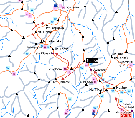
Sample hiking route
Distance (round trip): 35 km
Distance in elevation: 1,605 m
Difficulty during the best season: intermediate level
Trailhead: Iide Kousen
Route and estimated course time:
Iide Kousen -(0:50)- Osawa trailhead -(2:30)- Mt. Jizo -(1:30)- Mt. Mikuni -(1:50)- Kiriai-goya -(0:50)- Ubagongen -(2:45)- Mt. Iide -(2:00)- Onishi-goya -(2:00)- Mt. Dainichi -(1:40)- Onishi-goya -(1:30)- Lake Mitarashi -(1:30)- Mt. Eboshi -(0:50)- Kairagi-goya -(0:40)- Mt. Kitamata -(1:10)- Mt. Monnai -(1:40)- Mt. Kajikawa -(3:50)- Iide Sanso [28:25 in total]
Note: This example plan requires three nights and 4 days hiking. It is recomemnded for skilled hikers. Foods and futon (bed) are not available at every mountain hut except Kiriai-goya. In other words, hikers must bring enough foods for hiking and sleeping equipments.
Sample hiking route map

Hiking report
It is not available yet.
Directions
Public transportation
Tokyo Station -[JR Tohoku Shinkansen]- Koriyama Station -[JR Bannetsi-Saisen Line]- Yamato Station -[taxi]- Iide Kousen
Flight information/Timetable:
Tokyo Station to Koriyama Station: Ekitan
Koriyama Station to Yamato Station: Ekitan
Hot bath after hiking
Kairagiso(梅花皮荘)
Fee: 500 yen/adult
Bathing time: 10:00-19:00
Telephone: 0238-64-2111


