Mt. Ibuki
Location: Shiga
Elevation: 1,377 m
A mountain known as flower mountain and plenty of medicinal herb
Mt. Ibuki has been known that provided medicinal herb for the mountain from the acient time. Still, about 1200 species of medicinal herb grow naturally. Many tourists visit Mt. Ibuki in flower season since there is a surrounding road on the top that can access by bus.
Hiking
- Ibukiyama-tozanguchi: 6 hours 20 minutes (10.0 km)
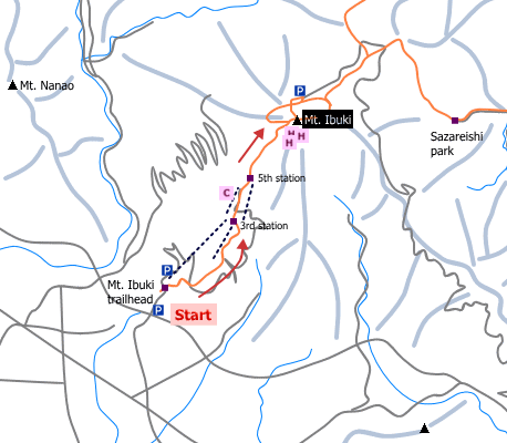
Sample route
Route: From Ibukiyama-tozanguchi
Distance: 10.0 km
Distance in elevation: 1,177 m
Difficulty during the best season: intermediate level
Season for hikers: late April to October
Route and estimated course time:
Ibukiyama-tozanguchi –[1:40]- 3rd station –[0:30]- 5th station –[1:40]- Mt. Ibuki –[1:05]- 5th station –[0:25]- 3rd station –[1:00]- Ibukiyama-tozanguchi [6 hours 20 minutes]
Description:
Gondra lift, which runs between trailhead and the 3rd station in seasons, is available for hikers who want to save times. The route is in the ski area. In other words, shade of trees cannot expect and it is very hot in summer. There are vending machines and toilet around 5th station. The route becomes zigzag from the 7th station. There are filed of wild grass and alpine flora around 9th station. You can meet lots of visitors because it can easily get there by car. There are a few shops on the mountaintop.
Route map

Hiking report
It is not available yet.
Directions
Public transportation
- Ibukiyama-tozanguchi: Ohmi-Nagaoka station -(bus)- Ibukiyama-tozanguchi
Area information
To be Noted


