Mt. Hijiri
Name in Japanese: HIjiri-dake (聖岳)
Location: Yamanashi, Shizuoka, Nagano
Elevation: 3,013 m
A magnificent mountain at the southernmost part of South Alps
Mt. Hijiri is the peak of a long and massive mountain system. A panorama view of South Alps is expected from the mountaintop. It should be a great joy when arrived the peak because it is a very long hike.
Hiking
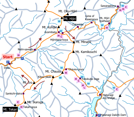
This sample route shown below is a traverse route from Mt. Hijiri to Mt. Tekari. A hike for 3 days 2 nights (or more) is recommended due to a long route. As of Dec 2016, only taxi is accessible to the trailhead (irodo) and it runs in summer season (until September 30). In case of hiking to Mt. Hijiri only, the route from Sawarashima is popular.
- From Irodo: 26 hours 30 minutes (35.5 km)
Sample route
Route: From Irodo
Distance: 35.5 km
Distance in elevation: 2,133 m
Difficulty during the best season: advanced level
Season for hikers: June to early November
Route and estimated course time:
[Day 1] Irodo -[1:15]- Nishi-sawado -[4:40]- Azamibata -[0:20]- Hijiridaira-koya [6 hours and 15 minutes for Day 1]
[Day 2] Hijiridaira-koya -[0:30]- Azamibata -[1:00]- Mt. Kohijiri -[1:20]- Mt. Hijiri -[0:50]- Mt. Kohijiri -[0:40]- Azamibata -[2:00]- Mt. Minami -[0:45]- Kamikouchi-dake-no-kata -[1:25]- Chaush-goya [8 hours and 30 minutes for Day 2]
[Day 3] Chaush-goya -[0:45]- Mt. Chausu -[0:50]- Kibou peak -[1:35]- Mt. Iro -[1:10]- Sakichi-daira -[1:15]- Tekari-goya -[0:20]- Mt. Tekari -[0:15]- Tekari-goya [6 hours and 10 minutes for Day 3]
[Day 4] Tekari-goya -[1:00]- Sakichi-daira -[1:15]- Mt. Iro -[3:20]- Irodo [5 hours and 35 minutes for Day 4]
Description:
Route map

Hiking report
It is not available yet.
Directions
Public transportation
- From Irodo: Hiraoka station -(taxi)- Irodo


