Mt. Hakusan
Name in Japanese: Haku-san (白山)
Location: Ishikawa, Gifu
Elevation: 2,702 m
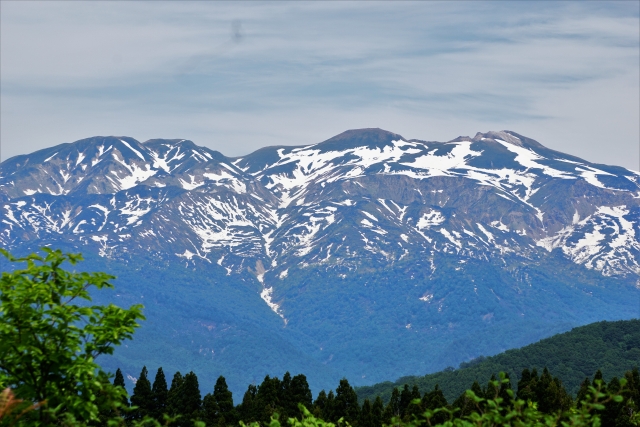
A beautiful mountain known for a spacious view and alpine flowers
Mt. Hakusan, together with Mt. Fuji and Mt. Tateyama, has been called as one of the sacred mountains since ancient times. As the name (Hakusan means white mountain) implies, its shining white shape can be seen from a great distance. There is a primeval forest of beeches from the foot to hillside of the mountain and alpine plants are abundant around mountain top. Although it is a long distance to walk, there is no dangerous place on the route and it is a popular mountain.
Hiking
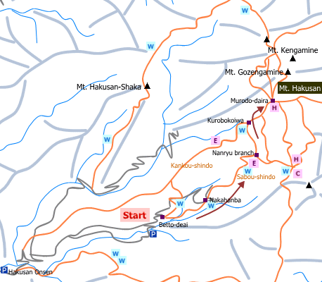
- From Betto-deai: 7 hours and 40 minutes (15.6 km)
Sample route
Route: From Betto-deai
Distance: 15.6 km
Distance in elevation: 1,442 m
Difficulty during the best season: intermediate level
Season for hikers: late June to late October
Route and estimated course time:
Betto-deai –[0:50]- Nakahanba –[1:50]- Nanryu branch –[0:50]- Kurobokoiwa –[0:30]- Murodo-daira –[0:40]- Mt. Gozengamine (Mt. Hakusan) –[0:30]- Murodo-daira –[0:20]- Kurobokoiwa –[0:40]- Nanryu branch –[1:00]- Nakahanba –[0:30]- Betto-deai [7 hours and 40 minutes]
Description:
To cross a suspension bridge soon after leaving Betto-deai, in order to walk Sabou-shindo (Sabou new route). The uphill trail on Sabou-shindo is rather a gentle slope. There are zigzag parts and steps on the route. Mt. Gozengamine, the highest peak of Mt. Hakusan, can be seen from Kurobokoiwa. Sabou-shindo joins Kankou-shindo at Murodo-daira. The peak is 30 minutes walk from here. If there is any time, to walk ‘Ike-meguri course’ from the peak is recommended.
Route map

Hiking report
It is not available yet.
Directions
Public transportation
- From Yashajin-touge trailhead: Kofu station -(taxi)- Yashajin-touge trailhead
Area information
To be Noted


