Mt. Fuji
Name in Japanese: Fuji-san (富士山)
Location: Yamanashi, Shizuoka
Elevation: 3,776 m
The highst mountain in Japan is popular even for foreigners
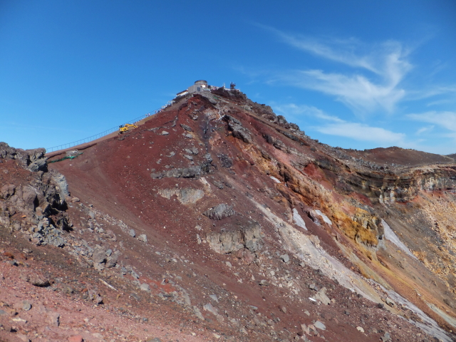
Mt. Fuji is a symbol mountain in Japan because of the highest peak in Japan and its beautiful shape. So many hikers climb Mt. Fuji during summer. Since Buddhist priests started climbing Mt. Fuji in Heian period (794-1184), number of hikers has been increased with the times. The highest trailhead is about 2300 m above the sea level. In other words, only less than 1500 m is the difference in altitude using this trail.
Hiking
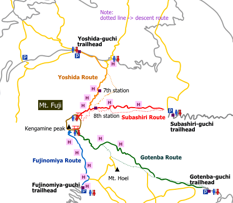
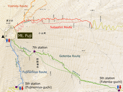
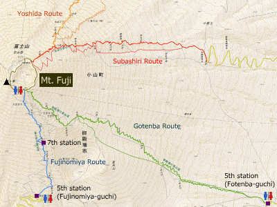
There are 4 major routes to Mt. Fuji.
- Yoshida Route: 9 hours 10 minutes (14 km)
- Subashiri Route: 9 hours 45 minutes (13 km)
- Gotenba Route: 11 hours 50 minutes (17.5 km)
- Fujinomiya Route: 8 hours 40 minutes (8.5 km)

Difficulty during the best season: intermediate level
Season for hikers: July to August
Note:
Because the elevation difference is smaller than the other route, almost 60% of hikers heading to the peak uses this route. In other words, this route is crowded in the season and there are many beginners. As the peak is over 3,500 meter above sea level, some people feel sick (high altitude disease). It is recommended to stay at a mountain hut due to long walk. Don’t leave warm clothes since the difference in temperature between the peak and mountain foot is about 20 degree Celsius.
Routes
1. Yoshida Route
Route: From Yoshida-guchi
Distance (round trip): about 14 km
Distance in elevation: about 1,400 m
Route and estimated course time:
5th station -[1:55]- 7th station -[4:00]- Kusushi Shrine -[0:50]- Edoya mountain hut (branch) -[2:25]- 5th station [9 hours 10 minutes]
Note:
This is the most major route among the four routes. This route is recommended to beginners because, for example, (1) the trailhead (Yoshida-guchui) is easy of access from Tokyo area, (2) there are many mountain huts, (3) there are three first-aid station. To put it the other way, this route is so crowded. It may hard to make a reservation of mountain hut. Due to lots of less experienced hikers, the trail can be also crowded.
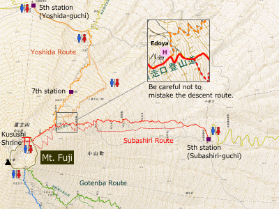
2. Subashiri Route
Route: From Sunashiri-guchi
Distance (round trip): about 13 km
Distance in elevation: about 1,800 m
Route and estimated course time:
5th station -[3:45]- 7th station -[3:00]- Kusushi Shrine -[0:50]- Edoya mountain hut (branch) -[2:10]- 5th station [9 hours 45 minutes]
Note:
Due to (maybe) the difference in elevation, not so many people use this route even in very high season. Hikers can walk at their own pace until the 8th station. It becomes crowded there because Subashiri Route and Yoshida Route join at the 8th station. For descent, hikers enjoy ‘Sunabashiri’. Sunabashiri is feeling kike a running on the snow. Hikers can go down the mountain faster.
3. Gotenba Route
Route: From Gotenba-guchi
Distance (round trip): about 17.5 km
Distance in elevation: about 2,300 m
Route and estimated course time:
5th station -[5:35]- 7th station -[2:45]- Ginmeisui -[1:25]- 7th station -[2:05]- 5th station [11 hours 50 minutes]
Note:
This is the longest route among the four routes. Because of this, it is less popular, so it is not crowded. As hikers using this route is not so many, there are not as many mountain huts as the other routes. In other words, there are less chance to go to restroom and to buy water. It many be tough route for beginners. Mt. Hoei (Hoei-zan), which is the newest crater of Mt. Fuji, can be accessible from Gotenba route.
4. Fuji nomiya Route
Route: From Fujinomiya-guchi
Distance (round trip): about 8.5 km
Distance in elevation: about 1,350 m
Route and estimated course time:
5th station -[2:15]- 7th station (original 7th station) -[2:55]- Komagatake -[2:00]- 7th station -[1:30]- 5th station [8 hours 40 minutes]
Note:
This is the shortest route among the four routes. The trailhead (Fujinomiya-guchi) is easiest of access from Kansai area. Moreover, the destination point (Komagatake) is closer to the higest peak (Kengamine). Hikers should be careful for altitude sickness because it is easy to gain height. In high season, this route may be crowded because the uphill trail and downhill trail is the same.
Hiking report
Coming soon.

Directions
Public transportation
- Yoshida route: Kawaguchiko station – Kawaguchiko 5th station (Fujikyu-Yamanashi bus)
- Subashiri route: Subashiri station – Subashiri 5th station (Fujikyu pass)
- Gotenba route:
- Fujinomiya route: Fujinomiya station – Fujinomiya 5th station (Fujikyu-Shizuoka bus)
Area information
Hot bath after hiking
Sensui (泉水)
Fee: 800 yen/adult
Bathing time: 10:00-23:00
Telephone: 0555-24-2438


