Mt. Daisen

Name in Japanese: Daisen (大山)
Location: Tottori
Elevation: 1,709 m
A beautiful mountain in Chugoku region known for Mountain Buddhism and a prodigious vision
Mt. Daisen is a composite volcano formed by lava dome on the top of stratovolcano. Mt. Daisen was introduced in Japanese mythology and had been attracting people as Okami-no-take (great god mountain). There are variety of alpine plants on the mountaintop including Daisen taxus cuspidata (national treasure). Due to its graceful figure like Mt. Fuji, it is also called Hoki-Fuji or Izumo-Fuji.
Hiking
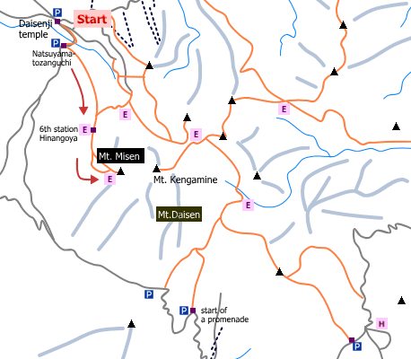
- From Daisenji temple: 5 hours 35 minutes (7.6 km)
Sample route
Route: From Daisenji temple
Distance: 7.6 km
Distance in elevation: 959 m
Difficulty during the best season: intermediate level
Season for hikers: late April to late November
Route and estimated course time:
Daisenji temple –[0:15]- Natsuyama-tozanguchi –[1:40]- 6th station Hinangoya –[1:20]- Mt. Misen (Mt. Daisen) –[1:00]- 6th station Hinangoya –[1:20]- Daisenji temple [5 hours 35 minutes]
Description:
The trail starts with the stone steps on a gentle slope. The trail climbed gradually from the 3rd station. It becomes a steeper from the 4th station, then it becomes a rocky trail from the 5th station. The part between the 6th station and 8th station, the ground is the sand gravel layer. This part is the steepest slope of the route. The trail becomes a wooden path from the 8th station and it should be a comfortable hike with the landscape for 360 degrees.
Route map

Hiking report
It is not available yet.
Directions
Public transportation
- Daisenji temple: Yonago station -(bus)- Daisenji temple
Area information
To be Noted


