Mt. Azuma

Location: Yamagata, Fukushima
Elevation: 2,035 m
1/25000 map: Tsuchiyu Onsen (土湯温泉), Tengendai (天元台), Azuma-san (吾妻山), Shirabu Onsen (白布温泉)
Season for hikers: early May to late October
A vast volcanoes ranging gentle mountains
Azuma Mountains is located on the border of Fukushima and Fukushima prefectures, and the highest peak is Mt. Nishi-azuma (West Azuma). Moor located at high altitude due to heavy snowfall, are beech tree forests, Abies mariesii primeval forests and Pinus pumila extend over the mountains. While the view from Mt. Nishiazuma is not good, the prospect from Mt. Issaikyo in Higashiazuma (East Azuma) is superb.
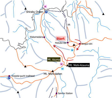
Sample hiking route
Distance (round trip): 9.2 km
Distance in elevation: 215 m
Difficulty during the best season: intermediate level
Trailhead: Hokubodai
Route and estimated course time:
Hokubodai -(0:50)- Ningyo-ishi -(2:30)- Mt. Nishi-Azuma -(1:30)- Wakamedaira -(1:50)- Shirabu Onsen [5:00 in total]
Note: It is an easy route as a ropeway and three lifts bring you to 1820 m above the sea level (Hokubodai). No view of surrounding mountains is expected on the route because of woody corridor.
Sample hiking route map

Hiking report
It is not available yet.
Directions
Public transportation
Tokyo Station -[JR Yamagata Shinkansen]- Yonezawa Station -[Yamako Bus]- Shirabu Onsen -[Tengendai Ropeway]- Hokubodai
Flight information/Timetable:
Tokyo Station to Yonezawa Station: Ekitan
Yonezawa Station to Shirabu Onsen: Yamako Bus
Tengendai Ropeway
Hot bath after hiking
Morinoyakata(森の館)
Fee: 395 yen/adult
Bathing time: 9:00-17:30
Telephone: 0238-55-2118


