Mt. Asahi

Location: Yamagata
Elevation: 1,870 m
1/25000 map: Uzenhayama (羽前葉山), Asahi-dake (朝日岳), Sagami-yama (相模山), Otoriike (大鳥池)
Season for hikers: early May to late October
The mountain expressed loftiness is covered with a beautiful primeval forest
Mt. Asahi, Mt. Oasahi as the highest peak, is located in the southern part of Tohoku and is a part of Bandai-Asahi National Park. While its elevation is less than 2,000 m above the sea level, snow gorges remain even in summer since it is a heavy snowfall area. This humid climate fosteres a variety of alpine plants and rich beech trees.
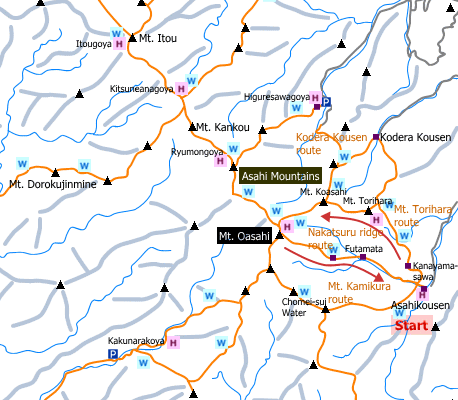
Sample hiking route
Distance (round trip): 18.1 km
Distance in elevation: 1,320 m
Difficulty during the best season: advanced level
Trailhead: Asahi kousen
Route and estimated course time:
Asahi Kousen -(1:25)- Kanayamasawa -(1:50)- Mt. Torihara -(1:40) Mt. Koasahi -(2:05)- Mt. Oasahi -(2:30)- Chomei-sui -(1:00)- Futamata -(1:40)-Asahi Kousen [12:10 in total]
Note: There is no remarkable dangerous points on the route. It is recommended to stay at a mountain hut because the route to the highest peak (Mt. Oasahi) is very long.
Sample hiking route map

Hiking report
It is not available yet.
Directions
Public transportation
Tokyo Station -[JR Yamagata Shinkansen]- Yamagata Station -[JR Aterazawa Line]- Aterazawa Station -[Asahi Tozan Bus]- Asahi Yamanoie
Flight information/Timetable:
Tokyo Station to Yamagata Station: Ekitan
Yamagata Station to Aterazawa Station: Ekitan
Aterazawa Station to Asahi Yamanoie: Information about hiking in Mr. Asahi
Hot bath after hiking
Naturalist-no-ie(朝日鉱泉ナチュラリストの家)
Fee: 500 yen/adult
Bathing time: 12:00-20:00
Telephone: 090-7664-5880


