Mt. Arashima
Location: Fukui
Elevation: 1,523 m
A beautiful mountain also called Ohno-Fuji
Mt. Arashima is an individual mountain, located in Ohno Basin, Fukui prefecture. It is also called as Ohno-Fuji. Hillside is covered with a Japanese beech forest and alpine flowers are abundant there. Seasonal scenery in Mt. Arashima, such as rhododendron in spring and silver frost in winter, is enjoyable. It has been the place of mountain worship and there is Arashima Shrine on the top of the mountain.
Hiking
- Nakande-tozanguchi: 6 hours (10.0 km)
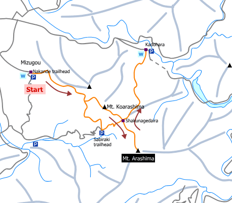
Sample route
Route: From Nakande-tozanguchi
Distance: 10.0 km
Distance in elevation: 1,428 m
Difficulty during the best season: intermediate level
Season for hikers: May to October
Route and estimated course time:
Nakande-tozanguchi –[2:00]- Mt. Koarashima –[0:20]- Shakunagedaira –[1:00]- Mt. Arashima –[0:40]- Shakunagedaira –[0:20]- Mt. Koarashima –[1:40]- Nakande-tozanguchi [6 hours]
Description:
Nakande route is a gentle slope compared with the other routes to Mt. Arashima. It is among trees and view of surrounding mountains cannot see until Mt. Koarashima. It is zigzag with ups and downs until Mt. Koarashima. From Mt. Koarshima, the route is on a large ridge. After passing shakunage-daira, the route becomes steeper. There are fixed ropes and chain places on rocky ridge.
Route map

Hiking report
It is not available yet.
Directions
Public transportation
- From Nakande-tozanguchi: Shimo-Yuino station -(50-minutes walk)- Nakande-tozanguchi
Area information
To be Noted


