Mt. Aizu-Komagatake

Location: Fukushima
Elevation: 2,133 m
1/25000 map: Aizu-Komagatake (会津駒ヶ岳), Hinoemata (檜枝岐)
Season for hikers: early June to late October
A famous mountain with becautiful high moor on the hillside
Mt. Aizu-Komagatake, noteworthy mounain in southern Aizu, is located in the northeast of Ozegahara. There is a vast stretch of high moor with meadow and ponds, and it is referred to as “the garden of the mountain”. There is folklore of fleeing Heike warriors in a local community close to the trailhead, and therefore, there is a teste of deep mountains and dark valleys. (Heike, used be a mighty ruler family in this country, fell in the 12th century.)
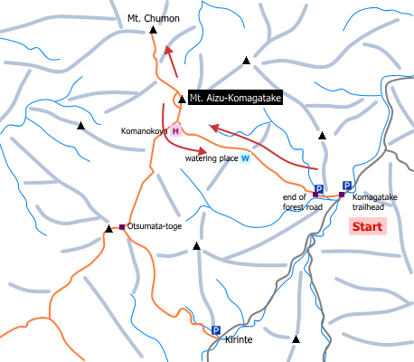
Sample hiking route
Distance (round trip): 14.1 km
Distance in elevation: 1,203 m
Difficulty during the best season: intermediate level
Trailhead: Komagatake-tozanguchi (Komagatake trailhead)
Route and estimated course time:
Komagatake trailhead -(0:40)- end of forest road -(1:30)- watering place -(1:30)- Komanokoya -(0:20)- Mt. Aizu-Komagatake -(0:50)- Mt. Chumon -(1:00)- Komanokoya -(1:10)- watering place -(1:10)- end of forest road -(0:30)- Komagatake trailhead [8:40 in total]
Note: Except rather steep slope between the end of forest road and Komanokoya, it is not a hard route. Start in early morning is recommended for hikers who hike this route just one dayt. It takes less than 7 hours without hiking to Mt. Chumon.
Sample hiking route map

Hiking report
It is not available yet.
Directions
Public transportation
Asakusa Station (Tokyo) -[Tobu Line]- Aizukogen-Oze-guchi Station -[Aizu Bus]- Komagatake-tozanguchi (trailhead)
Flight information/Timetable:
Asakusa Station to Aizukogen-Oze-guchi Station: Tobu Line (link to night train run in summer season)
Aizukogen-Oze-guchi Station to Komagatake-tozanguchi: Aizu Bus
Hot bath after hiking
Komanoyu(駒の湯)
Fee: 600 yen/adult
Bathing time: 6:00-21:00
Telephone: 0241-75-2655


