Mt. Poroshiri

Location: Hokkaido
Elevation: 2,052 m
1/25000 map: Poroshiridake (幌尻岳), Pipairodake (ピパイロ岳), Nukanraidake (ヌカンライ岳)
Season for hikers: late June to October
The highest peak of the Hidaka mountains – the Backbone of Hokkaido
Mt. Poroshiri is a towering mountain from the base, and ‘Poroshiri’ was derived from ‘Big Mountain’ in Ainu language. The mountain, as three curls with a traceable glacial epoch on the hillside, is a majestic sight. Although the view of Hidaka mountains from the peak is magnificient, it is one of the difficult mountains due to continuous stream walking.
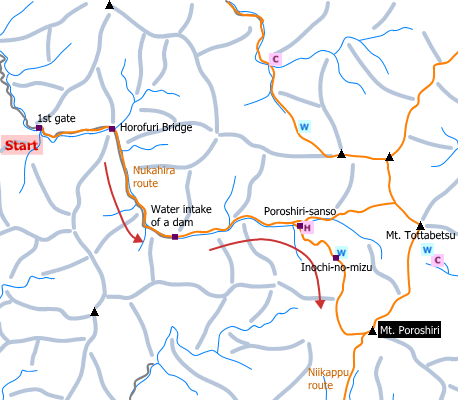
Sample hiking route
Distance (round trip): 23.2 km
Distance in elevation: 1,522 m
Difficulty during the best season: advanced level
Trailhead: 1st gate
Route and estimated course time:
1st gate -(1:40)- Water intake facility -(2:10)- Poroshiri-sanso -(1:50)- Inochi-no-mizu -(2:30)- Mt. Poroshiri -(1:40)- Inochi-no-mizu -(1:20)- Poroshiri-sanso -(1:50)- Water intake facility -(1:30)- 1st gate [14:30 in total]
Note: It is a long route with lots of wanding across river between Water intake facility and Poroshiri-sanso. It is better to bring Jika-tabi (rubber‐soled socks) for wanding. Hikers who plan to stay night should bring sleeping equipments as well as foods. Many hikers stay night at Nukabira-so before hiking and use a shuttle bus (reservation required) to the trailhead.
Sample hiking route map

Hiking report
It is not available yet.
Directions
Public transportation
Haneda Airport (Tokyo) -[Airline]- Shin-Chitose Airport (Sapporo) -[JR Hokkaido]- Minami Chitose -[JR Hokkaido]- Tomakomai -[Donan Bus]- Tomikawa-shigai -[taxi]- 1st gate (trailhead)
Flight information/Timetable:
Haneda Airport to Shin-Chitose Airport: Big Bird
Shin-Chitose Airport to Minami Chitose: New Chitose Airport Terminal
Minami Chitose to Tomakomai: JR Hokkaido
Tomakomai to Tomikawa0shigai: Donan Bus
Hot bath after hiking
Biratori Onsen(びらとり温泉)
Fee: 500 yen/adult
Bathing time: 10:00-21:00
Telephone: 01457-2-3280


