Mt. Kuju
Name in Japanese: Kuju-san (九重山)
Location: Oita
Elevation: 1,791 m
Hike to the highest peak of Kuju mountains through the flowering grasses
Mt. Kuju is the general term of mountains and it is also called the roof of Kushu region. Most of them are inactive volcanos covered with green fields. Cowberry, one of the natural treasures, blooms in the fields. The distance in elevation is small, in other words, the route is a gentle slope. So, it should be an enjoyable hiking.
Hiking
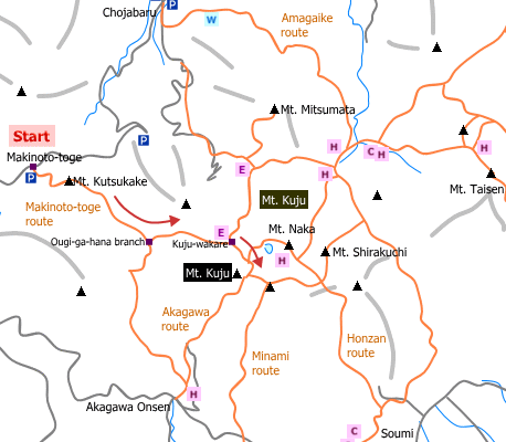
- From Makinoto-toge: 4 hours 50 minutes (9.0 km)
Sample route
Route: From Makinoto-toge
Distance: 9.0 km
Distance in elevation: 457 m
Difficulty during the best season: beginner level
Season for hikers: April to November
Route and estimated course time:
Makinoto-toge –[0:25]- Mt. Kutsukake –[0:45]- Ougi-ga-hana branch –[0:30]- Kuju-wakare –[1:00]- Mt. Kuju –[0:45]- Kuju-wakare –[0:30]- Ougi-ga-hana branch –[0:40]- Mt. Kutsukake –[0:15]- Makinoto-toge [4 hours 50 minutes]
Description:
The route starts as a paved road until an observation platform of Mt. Kutsukake. From there the route becomes comfortable one due to a gentle slope, good view and tiny flowers such as bilberries in the season. As the trail from Mt. Kutsukake is on a large ridge, be careful not to lost way in case that the visibility is poor.
Route map

Hiking report
It is not available yet.
Directions
Public transportation
- Makinoto-toge: Bungo-Nakamura station -(bus)- Makinoto-toge
Area information
To be Noted


