Mt. Kita
Name in Japanese: Kita-dake (北岳)
Location: Yamanashi, Shizuoka
Elevation: 3,192 m
2nd highest mountain in Japan is also well-known for rock climbing
Mt. Kita is the 2nd highest mountain in Japan and also called as Shiramine-sanzan together with Mt. Ainodake and Mt. Notori. A large rock face on East foot, called buttress, is the place that climbers admire. Mt. Kita stands on a major traverse route in southern Alps where abundant alpine flowers and a great view are expected.
Hiking
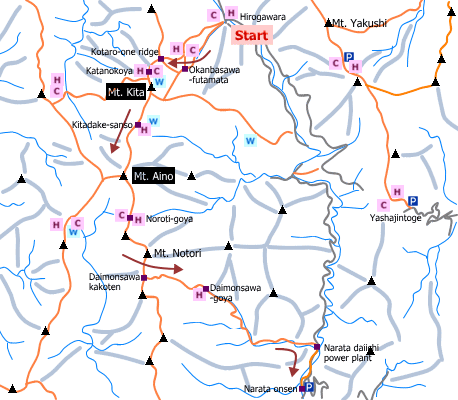
This sample route shown below is a traverse route from Mt. Kita to Mt. Aino. A hike for 3 days 2 nights is recommended due to a long route (staying at a mountain hut or camping is necessary). Mt. Kita and Mt. Aino are introduced in a book of the one hundred top mountains of Japan.
- From Hirogawara: 18 hours 20 minutes (24.5 km)
Sample route
Route: From Hirogawara
Distance: 24.5 km
Distance in elevation: 1,682 m
Difficulty during the best season: advanced level
Season for hikers: July to late October
Route and estimated course time:
[Day 1] Hirogawara -[2:30]- Okanbasawa-futamata -[2:30]- Kotaro-one ridge -[0:30]- Kita-dsake Kata-no-koya [5 hours and 30 minutes for Day 1]
[Day 2] Kita-dsake Kata-no-koya -[0:50]- Mt. Kita -[1:00]- Kita-dake-sanso -[1:40]- Mt. Aino -[1:00]- Noroti-goya [4 hours and 30 minutes for Day 2]
[Day 3] Please see Mt. Aino
Description:
There is no remarkable dangerous point on the route. There is a place with bad footing between Daimonsawa and Daimonsawa-goya. Caution is nesesary to step across a stream, especially when the river water increases.
Route map


Hiking report
It is not available yet.
Directions
Public transportation
- From Hirogawara: Kofu station -(bus)- Hirogawara
Area information
Hot bath after hiking
Momonoki Onsen ( 桃の木温泉)
Fee: 1,000 yen/adult
Bathing time: 11:00-18:00
Telephone: 055-288-2306


