Mt. Kayagatake

Name in Japanese: Kayagatake (茅ヶ岳)
Location: Yamanashi
Elevation: 1,703 m
Triangle-shaped mountain covered with broad‐leaved forest
Mt. Kayagatake together with Mt. kanegatake looks like Yatsugatake Mountains, so local people called it as ‘false Yatsugatake’ in the past. From the peak, great view of South Alps mountains is expected.
A hiking plan
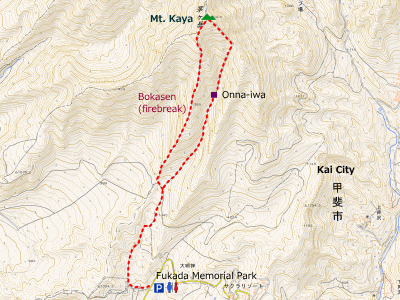
Fukada Kinen Koen (Fukada Memorial Park) -[1:20]- Onna Iwa -[1:00]- Mt. Kayagatake -(Bokasen route)- [2:00]- Fukada Kinen Koen [4 hours 20 minutes]

Hiking Info.
Distance: 6.5 km
Distance in elevation: 760 m
Best season for hikers: April to June / October to November
Summary of the course:
The trail starts with a forestry road that used to be a roadway. After passing Mae-Daimyojin rindo, it becomes a mountain path. The path is on a gentle slope until Onna-iwa. From Onna-iwa, the trail becomes a zigzag path, then comes to a rocky path. The peak is almost there if there are big rocks on the trail. A panoramic view is expected form the peak.
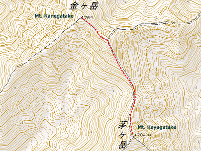
Many hikers continues to walk until Mt. kanegatake. Below map shows the route from Mt. kayagatake to Mt. Kanegatake.

Hiking report
None
How to get there
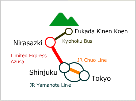
A bus to Fukada Kinen Koen is available from Nirasaki Station. There is a parking space at Fukada Kinen Koen.

Links
limited Express Azusa
Yamanashi Kyohoku Kotsu
Map around Mt. Kayagatake
Area Information
Hot bath after hiking
![]()
Hakusan Onsen
600 yen/adult
TEL: 0551-22-5050
7-min taxi ride
from Nirasaki Sta.


