Mt. Hakkoda

Location: Aomori
Elevation: 1,584 m
1/25000 map: Sukayu (酸ヶ湯), Hakkodasan (八甲田山), Moya (雲谷), Tashirotai (田代平)
Season for hikers: July to early October
Volcanic massif with beautiful wetlands and volcanic cone in northern end of Honshu
Mt. Hakkoda is located at the northern ōu mountain range, and is the collective name for a group of mountains. Mt. Hakkoda is mainly divided into 2 mountain ranges, North Hakkoda and South Hakkoda, and the highest summit is located at North Hakkoda. It belongs to Towada Hachimantai National Park.
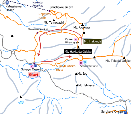
Sample hiking route
Distance (round trip): 10.0 km
Distance in elevation: 660 m
Difficulty during the best season: intermediate level
Trailhead: Sukayu Onsen
Route and estimated course time:
Sukayu Onsen -(1:20)- Sennintai hut -(0:50)- Hakkoda Otake (Mt. Hakkoda) -(0:55)- Kami-Kenashitai -(0:40)- Shimo-Kenashitai -(0:50)- Sukayu Onsen [4:35 in total]
Note: Mt. Hakkoda is consited of many peaks and small ponds. This route walk along, looking at the ponds and step many peaks. The easiest route to the peak (Hakkoda Otake) is from Sancho Koen (a repeway station). The distance in elevation between Sancho Koen and Hakkoda Otake is only 284 m.
Sample hiking route map

Hiking report
It is not available yet.
Directions
Public transportation
Haneda Airport (Tokyo) -[Airline]- Aomori Airport -[JR Bus Tohoku]- Aomori Station -[JR Bus Tohoku]- Sukayu Onsen (traihead)
Flight information/Timetable:
Sukayu Onsen (traihead)
Flight information/Timetable:
Haneda Airport to Aomori Airport: Aomori Airport
Aomori Airport to Aomori Station: Aomori Airport
Hirosaki Station to sukayu Onsen: JR Bus Tohoku
Hot bath after hiking
Sukayu Onsen(酸ヶ湯温泉)
Fee: 600 yen/adult
Bathing time: 7:00-17:30
Telephone: 017-738-6400
Remarks: This is a mixed bathing.


