Mt. Akaishi
Name in Japanese: Akaishi-dake (赤石岳)
Location: Shizuoka, Nagano
Elevation: 3,120 m
A magnificent mountain ahead of a long route
The shape of Mt. Akaishi, accompany Mt. Koakaishi in the north, is magnificent. Mt. Akaishi and Mt. Higashi locate in the deepest part of southern Alps. As it is tough to get there, many hikers traverse from Mt. Akaishi to Mt. Higashi.
Hiking
This sample route shown below is a traverse route from Mt. Higashi to Mt. Akaishi. A hike for 3 days 2 nights is recommended due to a long route (staying at a mountain hut or camping is necessary). Mt. Higashi and Mt. Akaishi are introduced in a book of the one hundred top mountains of Japan.
- From Sawarajma rodge: 19 hours 20 minutes (24.5 km)
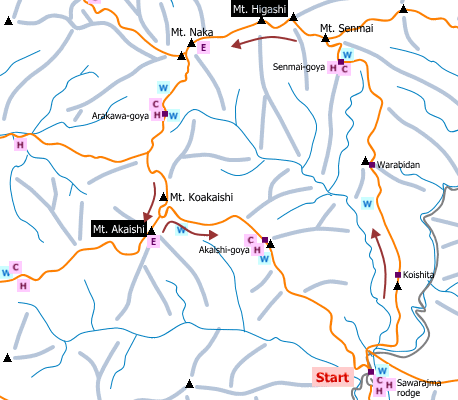
Sample route
Route: From Sawarajma rodge
Distance: 24.5 km
Distance in elevation: 1,751 m
Difficulty during the best season: advanced level
Season for hikers: July to early November
Route and estimated course time:
[Day 1] Sawarajima lodge -[2:15]- Koishita -[1:50]- Warabidan -[2:25]- Senmai-goya [6 hours and 30 minutes for Day 1]
[Day 2] Senmai-goya -[0:50]- Mt. Senmai -[1:25]- Mt. Higashi -[1:05]- Mt. Naka -[1:10]- Arakawa-goya -[0:40]- Daishoji-daira -[1:00]- Mt. Koakaishi -[0:55]- Mt. Akaishi -[2:15]- Akaishi-goya [9 hours and 20 minutes for Day 2]
[Day 3] Akaishi-goya -[3:30]- Sawarajima lodge [3 hours and 30 minutes for Day 3]
Description:
For Senmai-goya, it is an uphill trail (alternately gentle ascent and rather steep slope) and hikers proceed in an intent manner. Around Mt. Senmai, hikers should be careful for sliding down while walking a narrow pass. From Mt. Senmai, the route is on a mountain ridge and known as a strong wind. The upper slope continues until Mt. Higashi (Mt. Warusawa). From Mt. Naka to Arakawa-goya, it is a down slope. The steep slope becomes again from Arakawa-goya. As Mt. Akaishi is not on the traverse route (on the same mountain ridge), hikers usually left stuff at the branch to make a round trip to the peak. To Akaishi-goya, it is a down slope basically but ups and downs make hikers tired.
Route map

Hiking report
It is not available yet.
Directions
Public transportation
- From Sawarajma: Shizuoka station -(bus)- Hatanagi Dai-ichi dam -(bus)- Sawarajma
Area information
Hot bath after hiking
Shirakaba-so ( 赤石温泉 白樺荘)
Fee: 510 yen/adult
Bathing time: 10:00-17:00
Telephone: 054-260-2021


