Mt. Aino
Name in Japanese: Aino-dake (間ノ岳)
Location: Yamanashi, Shizuoka
Elevation: 3,189 m
4th highest mountain in Japan close to Mt. Kita
Mt. Ainodake is located in the centre of Shiramine-sanzan that is consist of Mt. Ainodake, Mt. Kita and Mt. Notori. The peak is at an altitude of 3189 meters and it is the 4th highest mountain in Japan. Summit and mountain ridge are broad and there is a cirque on East foot. Hikers usually hike all three mountains in Shiramine-sanzan. Not just Mt. Ainodake.
Hiking
This sample route shown below is a traverse route from Mt. Kita to Mt. Aino. A hike for 3 days 2 nights is recommended due to a long route (staying at a mountain hut or camping is necessary). Mt. Kita and Mt. Aino are introduced in a book of the one hundred top mountains of Japan.
- From Hirogawara: 18 hours 20 minutes (24.5 km)
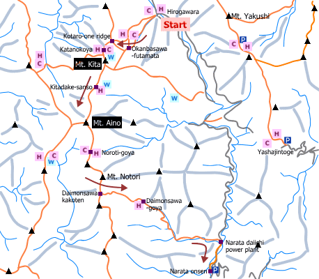
Sample route
Route: From Hirogawara
Distance: 24.5 km
Distance in elevation: 1,682 m
Difficulty during the best season: advanced level
Season for hikers: July to late October
Route and estimated course time:
[Day 1] Please see Mt. Kita
[Day 2] Kita-dsake Kata-no-koya -[0:50]- Mt. Kita -[1:00]- Kita-dake-sanso -[1:40]- Mt. Aino -[1:00]- Noroti-goya [4 hours and 30 minutes for Day 2]
[Day 3] Noroti-goya -[1:30]- Mt. Notori -[0:40]- Daimonsawa-kakoten -[2:30]- Daimonsawa-goya -[3:00]- Narata daiichi power plant -[0:40]- Narata onsen [4 hours and 30 minutes for Day 2]
Description:
There is no remarkable dangerous point on the route. There is a place with bad footing between Daimonsawa and Daimonsawa-goya. Caution is nesesary to step across a stream, especially when the river water increases.
Route map

Hiking report
It is not available yet.
Directions
Public transportation
- From Hirogawara: Kofu station -(bus)- Hirogawara
Area information
Hot bath after hiking
Momonoki Onsen ( 桃の木温泉)
Fee: 1,000 yen/adult
Bathing time: 11:00-18:00
Telephone: 055-288-2306


