Mt. Adatara

Location: Fukushima
Elevation: 1,700 m
1/25000 map: Adatara-yama (安達太良山)
Season for hikers: late May to October
Has long been famous for poems in an ancient anthology of Japanese poems, Manyoshu
Mt. Adatara is the primary peak of Adatara Mountains, ranging about 1,700 m high mountains. Mt. Adatara is also called as Mt. Chichikubi. The contrast of the desolated mountaintop by big eruption in 1900 and the forest zone on a hillside is magnificient. Traversing the ridges in Adatara Mountains has a lot of great views.
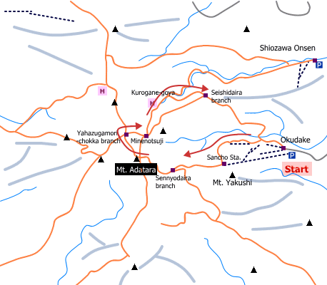
Sample hiking route
Distance (round trip): 10.5 km
Distance in elevation: 760 m
Difficulty during the best season: beginner level
Trailhead: Okudake
Route and estimated course time:
Okudake -(1:30)- Sancho Station -(0:35)- Sennyodaira branch -(0:30)- Mt. Adatara -(0:25)- Minenotsuji -(0:30)- Kurogane-goya -(0:25)- Seishidaira branch -(1:00)-Okudake [4:55 in total]
Note: The route is in good condition. Hikers as well as tourists visits this mountain as it takes about 1 hour to the peak of the moluntain by using a lift to Sancho Statoin. There is a hotspring on the route. There is no car access, in other words, only hikers can have a bath.
Sample hiking route map

Hiking report
It is not available yet.
Directions
Public transportation
Tokyo Station -[JR Tohoku Shinkansen]- Koriyama Station -[Koriyama Shuttle Bus]- Okudake
Flight information/Timetable:
Tokyo Station to Koriyama Station: Ekitan
Koriyama Station to Okudake: Higashi Sanbankan (Dake Onsen)
Hot bath after hiking
Dakenoyu(岳の湯)
Fee: 300 yen/adult
Bathing time: 10:00-20:30
Telephone: 0243-24-2139


